
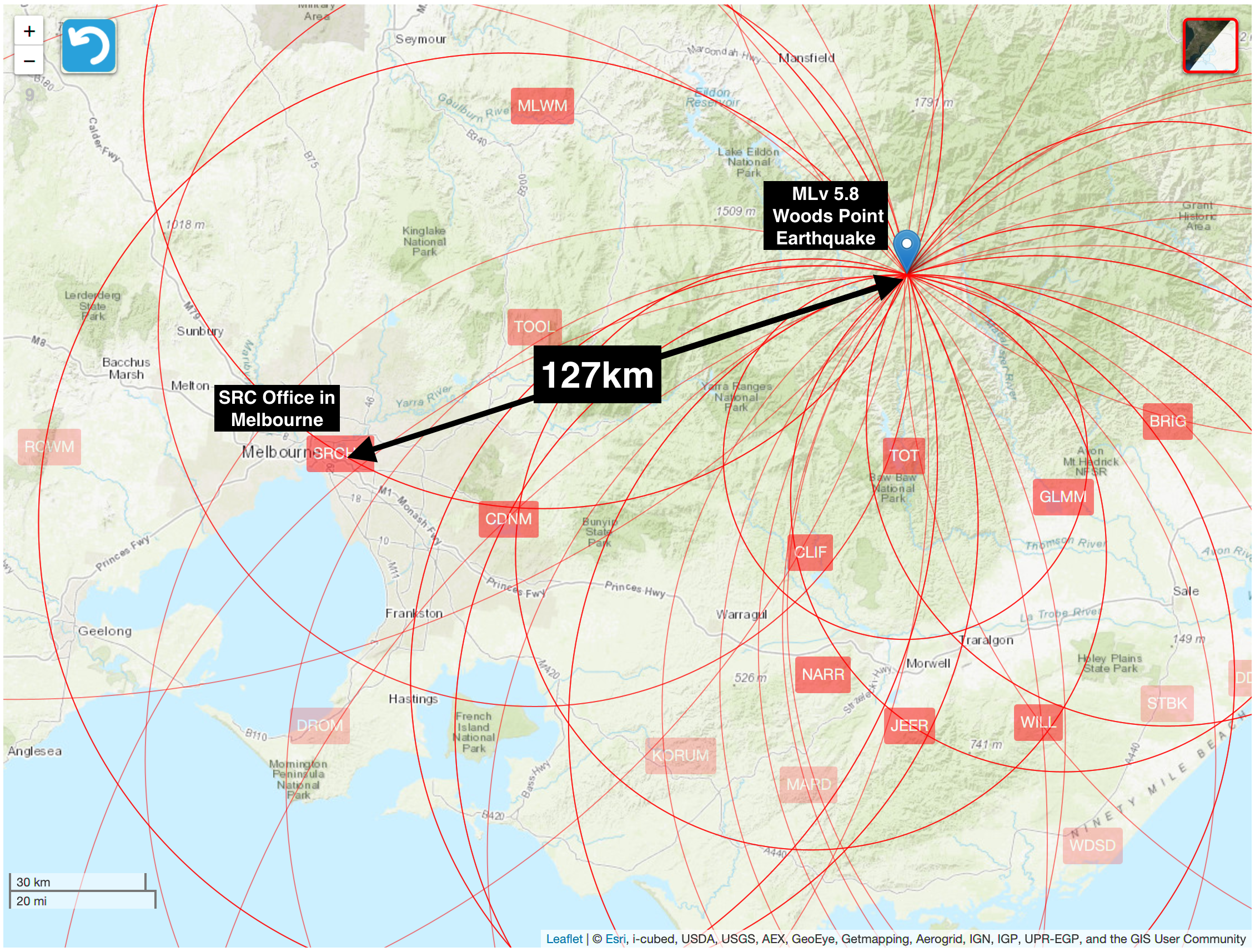
The magnitude MLv5.8 (Mw5.9) earthquake on 22 September 2021 at 9:15am local time was the largest to occur in the state of Victoria since record-keeping began around 200 years ago. The epicentre of the earthquake was located 127km from our office in Melbourne, and was recorded on an old digital seismograph operating in our factory where we manufacture our current range of earthquake recording equipment.
We have generated an isoseismal map of this earthquake based on data collected and contoured by Geoscience Australia. You can find GA’s raw data and more here.
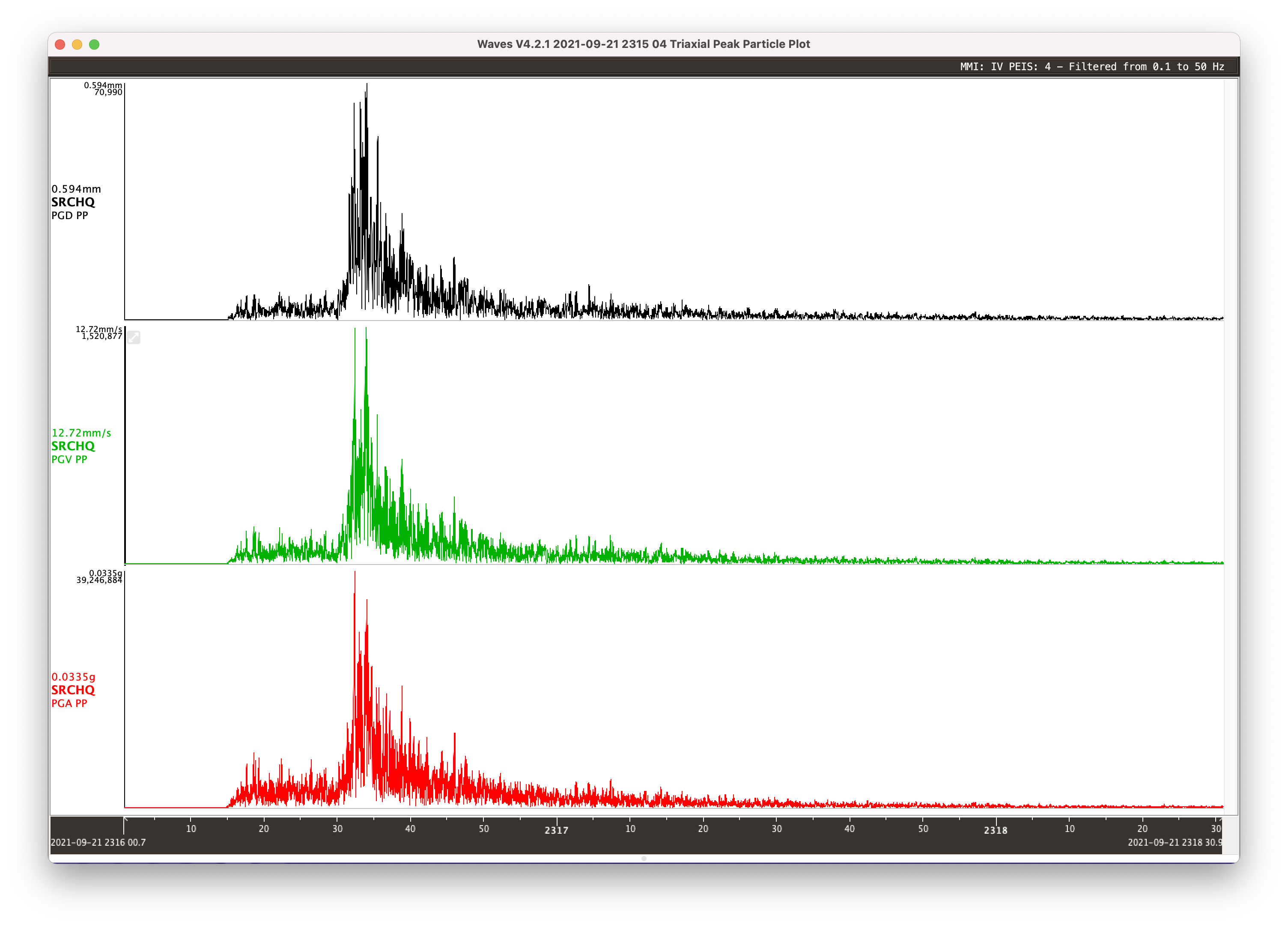
Download the data recorded at the SRC HQ here and download Waves to view and analyse the data.

Waves solution shows distance from SRC office and other seismograph stations to the Woods Point earthquake epicentre. 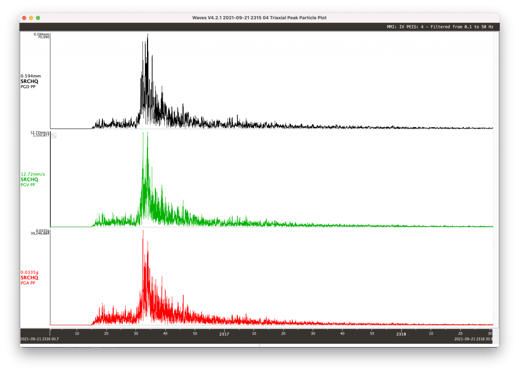
Peak ground velocity (PGV, green) at SRC office. Converted to PGA and PGD using Wave 3D vector sum feature 
Isoseismal map based on reported Modified Mercalli Intensity. It was felt in Sydney, Hobart, Adelaide and beyond

Below is summary of the earthquake that was prepared by Mark Quigley from the University of Melbourne, in conjunction with the SRC and Geoscience Australia.
INFORMATION SHEET
Release date: 27 September 2021
The moment magnitude (Mw) 5.9 Woods Point earthquake occurred at 9:15 am on Wednesday 22 September 2021 (AEST). More than 150 aftershocks of ML ≥ 1.0 have been recorded in the region as of 7:27 am Saturday 25 September AEST. The largest recorded aftershock is ML 4.2, recorded approximately 15 minutes after the Mw 5.9 mainshock.
The epicentre of this earthquake is approximately latitude -37.506o and longitude 146.402o. The epicentre is located approximately 56 km SE of Mansfield (bearing 150o) and 15 km ENE of Woods Point (bearing 060o). The preferred estimated hypocentre depth of this earthquake is approximately 12.7 km.
The earthquake has been named after the closest population centre (Woods Point) to the epicentre. Indigenous counsel has been sought as to whether a local Indigenous name for this earthquake would be culturally appropriate, and what name could be assigned if this is the case.
The preferred solution for the fault that ruptured in the earthquake is an approximately N-S oriented (bearing 350o), steeply dipping (ca. 85o), left lateral fault rupture.
On the basis of aftershock distributions, the estimated dimensions of the fault are LENGTH = 8 km, WIDTH = 9 km (ca. between 4 km to 13 km depth). The fault rupture process is inferred to be bi-lateral (N and S directed) and dominated by up-dip rupture propagation. The earthquake may have nucleated near the base of the brittle-ductile transition. The estimated average slip on the fault, considering a Mw range of 5.8 to 5.9, is approximately 0.25 to 0.40 m. Ten temporary seismometers were deployed in the aftershock area in 23 to 25 September; they are likely to be left in the field for several weeks.
Reconnaissance field inspections were undertaken from Thursday 23 September 2021 to Sunday 26 September 2021. Maps showing the roads and areas covered by field surveys are shown in the Appendix of this document.
Residents in the epicentral area report minimal-to-no structural damage to buildings and infrastructure. Only the most vulnerable of structures (ca. late 1800s to early 1900s unreinforced stone and masonry structures with poor mortar quality and very low capacity) were damaged. Many vulnerable structures were not damaged. Some light objects were displaced from shelves in some locations however many precarious objects were not displaced. Predicted MMIs (based on NGA-east Mw-based ground motion models for PGA) range from MMI > 5.5 to > 6.5 in populated areas within 40 km of the epicentre. Isolated local citizen reports include MMI 7. On the basis of our inspections, we tentatively suggest a MMI = 4 at distances of ca. 70 to 20 km from the epicentre and MMI =5 at distances ≤ 20 km from the epicentre. The most proximal instrumentally recorded horizontal peak ground accelerations are 0.11g, recorded at 63km hypocentral distance. Shaking durations and ground displacements and velocities may also have been relevant in considering the low amounts of damage in the epicentral region. This aspect is being currently investigated in more detail. “Did you feel it data?” can be used to gain deeper insights into the distribution and characteristics of shaking from this earthquake.
Reconnaissance road and bridge surveys were conducted. Rare, isolated areas are identified on maps where road cracking, typically perpendicular to the surrounding hillslope, is observed. These pose a potential hazard; we advise further monitoring of these features to assess whether further movement is evidenced. No damage to bridges (e.g., abutment and arch cracks, movement in talus slopes, road cracking) was observed.
Observed features indicative of environmental damage in the epicentre include:
- Spalling rocks from road cuts – includes detached individual rock fragments and joint- and bedding-controlled slab failures. Total maximum volumes of individual collapses <1-2 m2, total area of detached rocks typically < 1% of source area, up to a maximum of ca. 10% in isolated areas (rare).
- Rare, isolated rockfalls and boulder rolls in native (vegetated) areas; some boulder-tree impacts recorded.
- Shallow soil slides – maximum volumes < 2 m2, typically on or above steep-sided road cuts and below roads built on previously deposited colluvium / landslide deposits
- Individual tree fall and localized areas of clusters of fallen trees, including across roads.
- There is some evidence that azimuthal orientations of bedrock-soil cliffs and orientations of bedrock foliations and joints with respect to cliffs influenced failure mechanisms and intensity.
No field evidence has been found for ground surface rupture at this stage. This is as expected, given the preliminary fault model presented (top = 4 km below surface). It remains possible but highly unlikely that discrete ground surface rupture occurred. No evidence of liquefaction is found in alluvial and lake margin sediments. No evidence of deep bedrock landsliding is found. No evidence for rock mobility is found on mountainous summits near the epicentre (e.g., Mt Skene). InSAR imagery is currently under investigation to determine precise locations for further field analysis of environmental phenomena.
There is evidence for precarious rock features in the epicentral region that have not toppled in the earthquake. These include precariously-balanced rocks on steep hillslopes and loosely adhering rock fragments on road cuts.
On this basis we estimate peak ground accelerations in the epicentral area are unlikely to have exceeded 0.2g to 0.3g. This is the focus of further investigation.
The environmental effects caused by the Mw 5.9 Woods Point earthquake are located in areas where prior recent environmental effects (i.e., within last 1-10 years) of greater or equivalent intensity are evident (e.g., tree fall, rockfall, landsliding). The environmental effects are estimated to be equivalent to 1 to 10 years of residual “background” weathering with intermittent high rainfall events, and high wind events.
Aftershock rates have declined steadily since the Mw 5.9 mainshock. The last ML ≥ 3.0 aftershock was recorded on 23 September. We cannot refute the possibility of future significant earthquakes in the region.
FOR FURTHER INFORMATION ON THIS REPORT PLEASE CONTACT:
Mark Quigley (Report Lead Author), Associate Professor of Earthquake Science, School of Geography, Earth & Atmospheric Sciences, The University of Melbourne, also at: Seismology Research Centre Email: mark.quigley@unimelb.edu.au
Adam Pascale, Chief Scientist, Seismology Research Centre, a division of ESS Earth Sciences, 141 Palmer Street, Richmond VIC 3121, Australia, Email: adam.pascale@src.com.au
Dan Clark and Trevor Allen, Earthquake Hazard Activity: Place, Space and Communities Division | GEOSCIENCE AUSTRALIA: Dan.Clark@ga.gov.au , Trevor.Allen@ga.gov.au